Smarter Roads, Part 6: Sensing – What We Can Learn From Cameras First
In the first four parts of this series, we mapped the problem space. We looked at how defects form, why they escalate, and why most are still found too late.
In Part 5, we introduced the solution space, the structured landscape of all the credible, feasible, and publicly defensible ways we could close the detection gap. We broke that landscape into five interlocking domains:
- Sensing
- Models and Detection Logic
- Data Pipelines and Workflows
- Operational Integration
- Civic and Editorial Layer
This chapter begins the deep dive into those domains, starting with the foundation of any detection system: what we can actually sense.
Sensing is where every downstream choice begins. The hardware you mount, the angles you capture, the lighting you operate in, and the environmental constraints you accept all shape what is possible in the rest of the stack.
Because of this, sensing is the domain where early experimentation pays off the most.
Why Sensing Comes First
The detection gap is a system‑level issue: limited coverage, inconsistent reporting, slow triage, and the absence of a reliable early warning layer.
Road authorities require accurate, up‑to‑date condition information to manage the network effectively, yet most cracking is still assessed manually and infrequently. Traditional visual inspections are sparse, expensive, and slow, leaving large parts of the network unobserved for long periods.
If we can capture more of the network, more often, with enough fidelity to detect early‑stage defects, then everything else becomes easier, cheaper, and more predictable.
But sensing is also where the real‑world constraints hit hardest:
- changing light
- vibration at 40–80 km/h
- weather
- mounting limitations
- bandwidth and storage
- lens contamination
- power and thermal limits
Understanding these constraints is essential before we talk about models or pipelines. And to understand those constraints, we need to look closely at the sensing modalities available today and why cameras are the most practical place to start.
The Sensing Landscape
There are many ways to observe a road network. Each modality brings strengths, weaknesses, and operational implications.
Vision‑Based Cameras
- Rich visual detail
- Low cost, easy to mount
- Sensitive to lighting, motion blur, and contamination
- Strong foundation for ML and sensor fusion
Vibration Sensors (Accelerometers and IMUs)
- Cheap and robust
- Detect roughness indirectly
- Strongly influenced by vehicle dynamics
- Best as a complementary signal
LiDAR
- High‑precision 3D geometry
- Excellent for profiling
- Expensive and weather‑sensitive
- Suited to specialised deployments
Radar
- Weather‑resistant
- Lower resolution than LiDAR
Why Start With Cameras
Cameras offer the best balance of:
- cost
- ease of mounting
- data richness
- compatibility with modern ML models
- scalability across council or fleet vehicles
They also allow us to explore the primary levers in the sensing domain.
Primary Levers
- sensor type and quality
- lens choice and field of view
- mounting position and vibration behaviour
- exposure, shutter speed, and capture rate
- environmental resilience (light, rain, dust)
- integration with edge devices (Pi, Jetson, smartphone)
Key Trade‑offs
- cost versus fidelity
- resolution versus bandwidth
- wide field of view versus geometric distortion
- fixed focus versus autofocus stability
- stabilisation versus power consumption
- daylight performance versus low‑light reliability
Austroads highlights that pavement condition measurement technologies must deliver reliable, repeatable data, operate effectively under real‑world environmental conditions, and be practical for network‑level deployment, as reflected in the guidance on field surveys and surface‑testing equipment [1].
Councils also care about:
- predictable operating costs
- minimal staff burden
- clear evidence that the system works
- outputs that integrate cleanly into existing workflows
These are the same levers and trade‑offs that will appear again when we explore LiDAR, IMUs, and sensor fusion, but cameras give us the fastest, cheapest way to start learning.
Constraints That Shape Camera Performance
Real‑world deployment means designing around constraints, not ignoring them.
Optical Constraints
- low‑light performance
- dynamic range
- shutter speed and motion blur
- resolution versus processing load
- focus stability
Mechanical Constraints
- mounting and vibration
- rolling‑shutter artefacts
- lens contamination
- field of view and distortion
System Constraints
- edge versus cloud processing
- power and thermal limits
- storage and bandwidth
- integration with existing hardware
Comparing Practical Camera Options
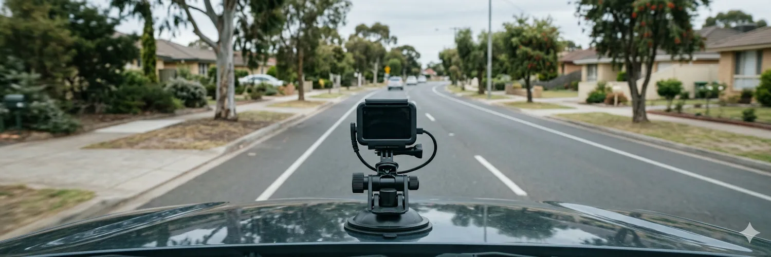
We now compare three modern camera categories: action camera, mid‑range smartphone, and embedded camera module. The GoPro Hero 13 Black (2024), Samsung Galaxy A56 (2025), and Raspberry Pi Camera Module 3 (2023) together bracket the practical design space for modern sensing systems, providing optical, consumer‑grade, and embedded baselines respectively.
Optical Constraints
These determine how well a camera captures usable detail under real road conditions, especially at speed, in mixed light, and across varying surface textures.
| Camera Model | Sensor | Sensor Size | Low Light Performance | Dynamic Range | Motion Blur Resistance | Focus Behaviour | Resolution Impact |
|---|---|---|---|---|---|---|---|
| Raspberry Pi Cam 3 | Sony IMX708 | 1/2.43‑inch (1.4 µm effective pixels) | Moderate | Moderate | Sensitive to blur at higher speeds | Motorised fixed focus, stable once set | 12 MP (3 MP effective) |
| GoPro Hero 13 Black | Sony STARVIS 2 | 1/1.9‑inch (1.7 µm pixels) | Very good | High | Very strong (HyperSmooth 7.0 + shutter bias) | Fixed focus | 27 MP |
| Samsung Galaxy A56 | Samsung ISOCELL | 1/1.7‑inch (1.6 µm effective pixels) | Good | High | Moderate (OIS + EIS; fusion can smear texture) | Autofocus; can hunt | 50–64 MP (12–16 MP effective) |
Mechanical Constraints
These shape how the camera behaves once mounted on a moving vehicle: vibration, angle, contamination, and physical robustness.
| Camera Model | Vibration Handling | Mounting Robustness | Rolling Shutter Artefacts | Lens Contamination Risk | Field of View Characteristics |
|---|---|---|---|---|---|
| Raspberry Pi Cam 3 | Moderate (mount dependent) | Moderate | Noticeable at speed | Exposed lens; needs housing | Narrow FOV (Narrow variant) |
| GoPro Hero 13 Black | High (action‑tuned) | High | Well controlled | Excellent sealing | Very wide FOV; distortion manageable in Linear mode |
| Samsung Galaxy A56 | Moderate | Moderate | Can wobble under vibration | Consumer‑grade sealing | Wide FOV; balanced distortion |
System Constraints
These determine how easily the camera integrates into a sensing workflow: power, processing, storage, and connectivity.
| Camera Model | Power & Thermal Behaviour | Storage & Bandwidth | Integration with Edge Devices | Workflow Fit | Cost |
|---|---|---|---|---|---|
| Raspberry Pi Cam 3 | low power; minimal heat | configurable | Seamless | Very high | Mid range* |
| GoPro Hero 13 Black | Higher power; thermals manageable | somewhat configurable | Limited direct integration | Moderate | High (A$500–A$600) |
| Samsung Galaxy A56 | Moderate power; thermals manageable | configurable | Integration via apps/APIs | Moderate | Mid range (A$400–A$500) |
*A$400–A$500 including Pi 4/5 & case
Interpretation:
The PiCam 3 is the easiest to integrate and the most deterministic. The GoPro produces the richest data but at the highest operational cost. The Galaxy A56 again sits in the middle with limited hardware integration but flexible software integration.
Where This Leads
A clear pattern emerges: each platform anchors a different part of the sensing landscape.
- The GoPro Hero 13 provides the strongest optical baseline for early experimentation.
- The Galaxy A56 shows what is feasible with the devices citizens already carry.
- The PiCam 3 shows what becomes possible when sensing is integrated with LiDAR, IMUs, GPS, and edge compute.
| Sensor | OPTICAL | MECHANICAL | SYSTEM |
|---|---|---|---|
| GoPro Hero 13 | ●●● | ●●● | ● |
| Galaxy A56 | ●● | ●● | ●● |
| PiCam 3 | ● | ● | ●●● |
Legend: ●●● strong, ●● moderate, ● weak
Platform Selection Matrix
| Platform | Strengths | Weaknesses | Best Use Case |
|---|---|---|---|
| GoPro Hero 13 | Best optical quality; excellent stabilisation; strong low‑light performance | Harder to integrate; large files; higher cost | Establishing optical baselines; early high‑fidelity experiments |
| Samsung Galaxy A56 | Economical; widely available; many built‑in sensors | Less deterministic; motion fusion can smear texture | Citizen reporting; community sensing; low‑cost pilots |
| Raspberry Pi Cam 3 | Fully integrable; deterministic; low power; easy to pair with LiDAR and IMUs | Weaker optics; sensitive to vibration; requires careful mounting | Scalable sensing systems; fleet integration; long‑term deployments |