Smarter Roads, Part 5: The Solution Space
In the first four parts of this series, we mapped the problem space. We looked at how defects form, why they escalate, and why most are still found too late.
Now we turn to the forward‑looking question: what can we actually do about it?
This chapter introduces the solution space, which is the structured landscape of all the credible ways we could close the detection gap.
It is the organised set of feasible, testable, and publicly defensible pathways forward.
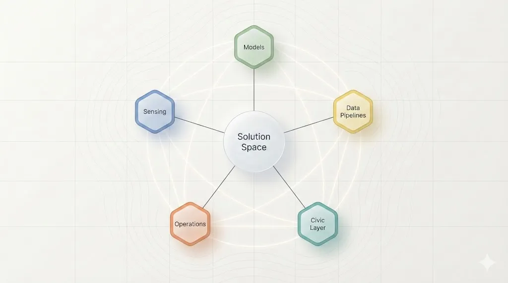
What the Solution Space Is
A well‑defined solution space helps us move from “what is broken” to “what is possible.”
It spans the technical, operational, and civic dimensions that shape any real‑world sensing system.
For this project, the solution space covers five interlocking domains:
- Sensing. The hardware and modalities we can use to observe the road network.
- Models and Detection Logic. How raw imagery becomes meaningful signals.
- Data Pipelines and Workflows. How data is stored, processed, governed, and made reproducible.
- Operational Integration. How councils and crews actually use the outputs.
- Civic and Editorial Layer. How the system earns trust through transparency and communication.
A clear solution space does three things:
- It makes trade‑offs visible, such as cost versus accuracy or simplicity versus scalability.
- It reveals dependencies, such as which options require new hardware, workflows, or governance.
- It supports staged experimentation, including what can be trialled cheaply, what needs field testing, and what requires long‑term investment.
The Five Domains at a Glance
| Domain | What It Covers | Primary Levers | Key Trade‑offs | What Councils Care About |
|---|---|---|---|---|
| Sensing | Cameras, LiDAR, mounting, power, environmental resilience | Hardware choice, placement, capture rate, exposure logic | Cost versus fidelity, simplicity versus robustness | Reliability, weather tolerance, cost to deploy |
| Models and Detection Logic | Open‑source models, rule‑based logic, training data, inference speed | Model architecture, thresholds, explainability | Accuracy versus compute cost, openness versus performance | Transparency, false positives, ease of auditing |
| Data Pipelines and Workflows | Storage, metadata, provenance, reproducibility, automation | File formats, EXIF, logs, queueing, processing | Speed versus auditability, automation versus oversight | Data retention, privacy, system integration |
| Operational Integration | Deployment models, maintenance, monitoring, crew workflows | Mounting strategy, update cadence, watchdogs | Autonomy versus manual control, cost versus resilience | Predictability, maintainability, minimal staff burden |
| Civic and Editorial Layer | Public communication, privacy framing, transparency | Documentation, visual assets, reporting cadence | Detail versus clarity, openness versus risk | Trust, legitimacy, community expectations |
Why This Matters Now
The detection gap is not caused by a single failure point.
It is a system‑level issue that includes limited sensing coverage, inconsistent reporting, slow triage, and the absence of a reliable early‑warning layer.
The solution space reflects that complexity.
There is no single fix. Instead, there are multiple viable pathways, each with different costs, risks, and operational implications.
Some options can be trialled cheaply with the hardware we already have.
Others require new sensing modalities or new governance structures.
Some improve accuracy, while others improve reliability or auditability.
The goal isn’t to pick a winner today.
It is to make the landscape clear enough that councils, practitioners, and communities can make informed choices.
What’s Next
In the next chapter, we will start exploring these domains in detail, beginning with sensing.
We will define some experiments to help us better understand what is possible with different cameras and what is not.
From there, we will build up through other sensors, models, pipelines, operational integration, and finally the civic layer that determines whether any of this earns public trust.
Mapping it is the first step toward closing the detection gap.